Buckinghamshire Council
Tree preservation zone
There is a problem
- 1000 entries with tree-preservation-order field must match the reference field in the tree preservation order dataset
The Bucks County Council (Eton Rural District) Tree Preservation Order No. 1; 1958; under S.28 of th
- reference
- ZZZZZSESRW435
- name
- The Bucks County Council (Eton Rural District) Tree Preservation Order No. 1; 1958; under S.28 of th
- tree-preservation-order
- TPO/BD/1958/01
- tree-preservation-zone-type
- geometry
- MULTIPOLYGON (((-0.691967 51.529864,-0.691954 51.529829,-0.691906 51.529722,-0.691892 51.529699,-0.691874 51.529664,-0.691857 51.529646,-0.691849 51.529640,-0.691791 51.529507,-0.691798 51.529481,-0.691770 51.529349,-0.691761 51.529279,-0.691763 51.529238,-0.691762 51.529170,-0.691763 51.529144,-0.691768 51.529109,-0.691778 51.529064,-0.691796 51.528968,-0.691797 51.528953,-0.691790 51.528942,-0.691780 51.528936,-0.691729 51.528879,-0.691755 51.528874,-0.691771 51.528868,-0.691795 51.528850,-0.691798 51.528845,-0.691799 51.528788,-0.691803 51.528747,-0.691808 51.528575,-0.691812 51.528498,-0.691791 51.528185,-0.691797 51.528020,-0.691798 51.527802,-0.691797 51.527772,-0.691811 51.527494,-0.691676 51.527341,-0.691675 51.527342,-0.691665 51.527335,-0.690446 51.527437,-0.690461 51.527622,-0.690456 51.527648,-0.690446 51.527680,-0.690425 51.527737,-0.689749 51.527781,-0.689016 51.527833,-0.689044 51.528122,-0.689087 51.528419,-0.689094 51.528452,-0.689163 51.528683,-0.689176 51.528709,-0.689207 51.528786,-0.689227 51.528829,-0.689295 51.528959,-0.689347 51.528955,-0.689559 51.528933,-0.690289 51.528852,-0.690298 51.528987,-0.690297 51.528992,-0.690304 51.529044,-0.690306 51.529094,-0.690314 51.529136,-0.690315 51.529155,-0.690479 51.529137,-0.690476 51.529129,-0.690638 51.529110,-0.690727 51.529096,-0.690744 51.529098,-0.690796 51.529109,-0.690814 51.529118,-0.690829 51.529134,-0.690839 51.529139,-0.690873 51.529151,-0.690884 51.529160,-0.690873 51.529182,-0.690869 51.529197,-0.690867 51.529218,-0.690872 51.529228,-0.690902 51.529339,-0.690803 51.529349,-0.690784 51.529380,-0.690777 51.529396,-0.690771 51.529416,-0.690775 51.529424,-0.690780 51.529442,-0.690783 51.529476,-0.690748 51.529519,-0.690740 51.529533,-0.690728 51.529561,-0.690721 51.529588,-0.690719 51.529603,-0.690711 51.529605,-0.690732 51.529672,-0.690756 51.529728,-0.690772 51.529761,-0.690822 51.529850,-0.690868 51.529928,-0.690911 51.529988,-0.691025 51.529995,-0.691103 51.530010,-0.691574 51.529933,-0.691949 51.529876,-0.691946 51.529867,-0.691967 51.529864)))
- point
- POINT (-0.690722 51.528519)
- notes
- entry-date
- 2017-07-04
- start-date
- 2017-07-04
- end-date
How to fix this issue
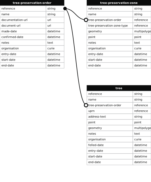
Your data is missing a tree-preservation-order.
The tree preservation zone guidance explains how to fix the issue:
tree-preservation-order
The reference for the tree preservation order that covers this zone.
How to improve Buckinghamshire Council’s data
- Fix the errors indicated
- Use the check service to make sure the data meets the standard
- Publish the updated data on the endpoint URL